
Spaceborne Radar Remote Sensing
- Typ: Lecture, Tutorial and Computer Workshop
- Zielgruppe: Master
- Lehrstuhl: IHE
- Semester: SS 2026
-
Ort:
Lecture and Tutorial: NTI lecture hall
Computer Workshop: 20.21 Pool B
-
Zeit:
Lecture and Tutorial:
Thursday, 15:45-18:00
Computer Workshop:
Thursday, 14:00-15:30 - Beginn: 23.04.2026
- Dozent:
- SWS: 4
- ECTS: 6
- LVNr.: Lecture: 2308428; Exercise: 2308429; PC-Workshop 2308427
-
Prüfung:
Written, 2 hours, date see here
Composition of grades 67% written exam, 33% SAR workshop -
Hinweis:
Lecture material, schedule and further information available through ILIAS
Short Description
The lecture covers aspects of spaceborne radar systems as well as an overview of new technologies and future developments. Spaceborne radar represents an emerging technology in space systems since no other sensor is able to produce high-resolution images of the Earth surface independent on the weather conditions and day-light illumination. The interdisciplinary lecture is well suited for students at the master level interested in learning different aspects of the entire end-to-end system chain of spaceborne radar systems. The syllabus of the lecture are coordinated together with the tutorial and the computer workshop. All three are needed for a thorough understanding of the lecture material.

TanDEM-X mission with two radar satellites flying in close formation has generated a global, high-resolution digital elevation model (DEM) of the Earth with unprecedented accuracy.
Syllables
- Introduction to Synthetic Aperture Radar (SAR)
- Theory and basic signal processing
- System design and performance estimation
- Advanced SAR imaging modes
- Spaceborne SAR missions:
SRTM, ENVISAT, TerraSAR-X, TanDEM-X, Tandem-L, Sentinel-1 - Technology development
- Interferometry and tomography
- Applications (land, vegetation, sea, ice/snow, disaster monitoring)
- Other types of spaceborne radars (altimeter, weather radar, etc.)
- New SAR concepts & future developments

Digital Elevation Model (DEM) generated by the TanDEM-X mission: Perspective view of the Krascheninnikov Caldera (in the front) and the 3528m high Kronotsky volcano with a particularly symmetrical conical shape. At the horizon on the left one can recognize the Kljutschevskoi volcano, with 4835m the highest peak in Kamchatka, Russia.
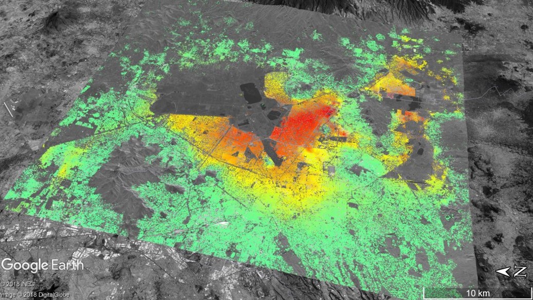
“Seventy Sentinel-1A images acquired between 2015 and 2017 were processed to obtain this image of ground deformation in Mexico City. The deformation is caused by ground water extraction, with some areas of the city subsiding at up to 2 cm/month (red). Copyright: Copernicus data (2015)/ESA/DLR Microwaves and Radar Institute.”